Searching for maps identifying surface water quality in the United States through a Google search on Chrome, here are some of the most relevant results from federal and state governmental sources:
WaterQualityWatch
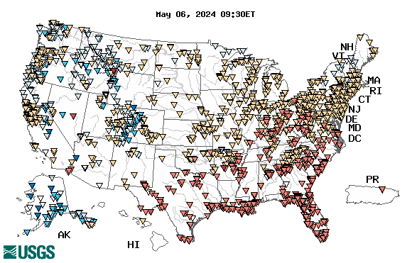
USGS creates “Real-time” maps which track short-term changes (over several hours) of water quality. Although the general appearance of the map changes very little from one hour to the next, individual sites may change rapidly in response to major rain events or to reservoir releases. The data used to produce this map are provisional. Continuous real-time water quality of surface water in the United States
EPA’s Water Data and Tools
For instance, the EPA provides Ambient Water Quality tools track water quality data and their impacts to the environment and human health, including such specific data as mapping fish advisory.
Surface Water Quality Maps
States have created their own surface water quality maps. For instance, this Texas interactive map viewer allows users to view the stream segments and water bodies (including impairment status) for any body of water in Texas that the TCEQ monitors. Surface Water Quality Monitoring (SWQM) Stations are also included in the viewer.
